

MUNICIPALITIES
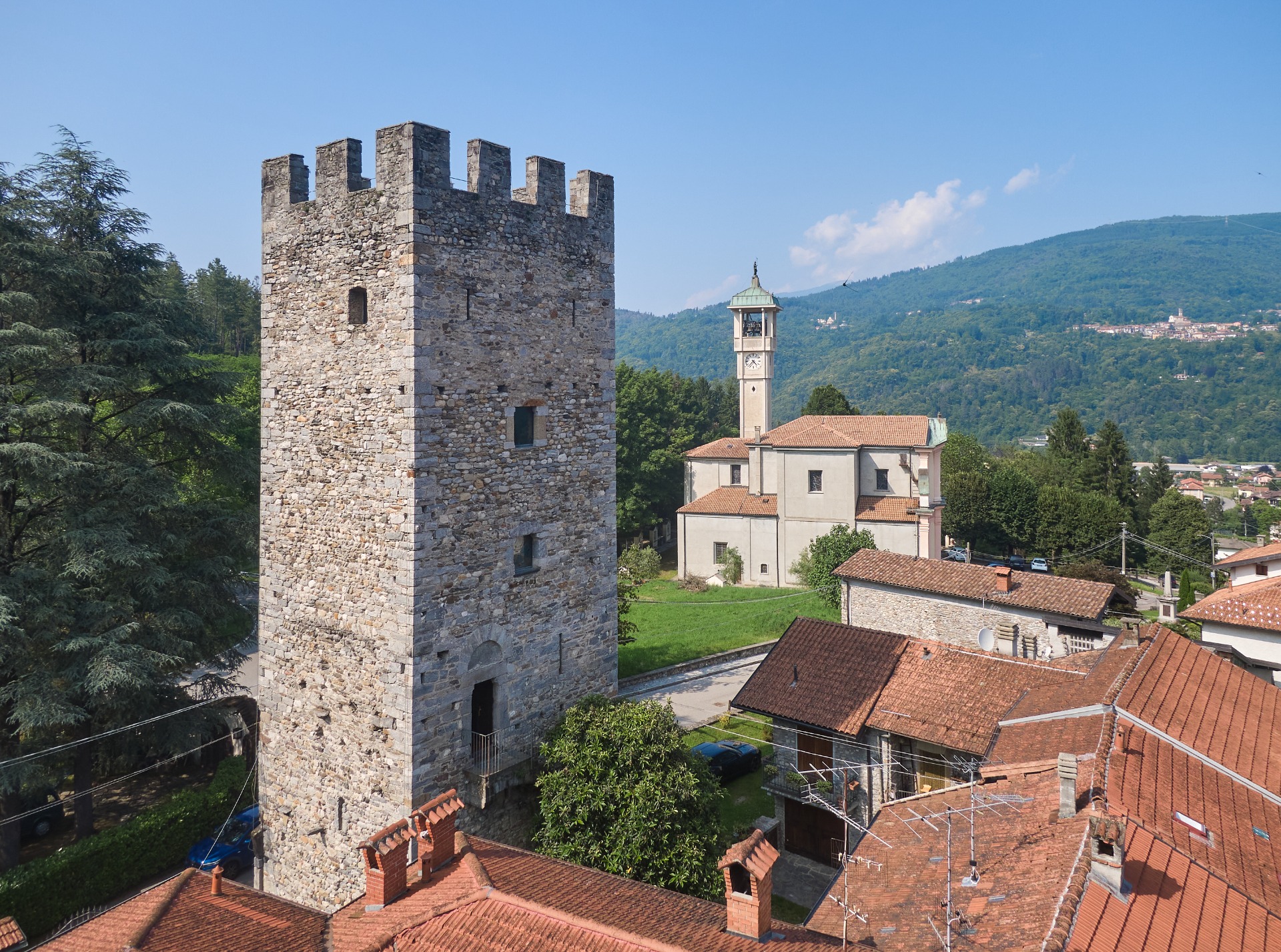
AGRA
The country of Agra, with its 384 inhabitants, is located in a dominant position overlooking Lake Maggiore, between 680 and 740 m above sea level, from which almost the entire basin can be observed.
It is remembered in the 13th century as "San Martino de Agra", and the name "Agra" derives from the Latin acer (steel).
No prehistoric settlements have been found and it is presumed that the first permanent inhabitants date back to around the year 1000. The oldest religious building dates back to the 12th-13th century, while the three watchtowers, long since transformed into the bell towers of the churches of Dumenza, Agra and Campagnano, date back to the period between 900 and 1000.
Local chronicles describe events that bring to mind moments of great historical relevance, such as the plague of Manzoni's memory, with the burial of the plague dead at the mé di mort (Mount of the Dead), on which the Church of the Blessed Virgin of Mount Carmel was built in 1838. The Agrese chronicles also recall the pastoral visits of Cardinal Carlo Borromeo.
Characteristic features of the town are the ancient houses with their "lobbie", balconies made of beech, chestnut and hazel wood planks, also used for interior furnishings.
The parish church is dedicated to Saint Eusebius. Built between 1931 and 1933, it is partly constructed with materials from the old San Rocco building, but it preserves some frescoes painted in 1959 by the painter Rivetta. There are three other churches: Madonna del Carmine, Madonna della Lupera, and the Sanctuary of Santa Maria Madre della Chiesa San Giuseppe.
Of particular naturalistic and tourist interest are the two walks, the Giro del Sole and the Giro della Luna, with the Mandelli and Zuccoli viewpoints offering walkers splendid views of the lake.
The village also has a Deer Park that is home to both deer and goats and also has a nice playground for children.
The "Pumpkin Festival" takes place in October, a traditional event that every year brings together thousands of people eager to taste pumpkin-based delicacies and discover the numerous stalls dotting the streets of the town center.


AZZIO
Azzio is a pleasant hilltop village in Valcuvia, located at 400 meters above sea level. With its 2.17 square kilometers of surface, it is characterized by the presence of abundant spring water, which collects in the Bulgherone, Viganella and Boesio rivers, and is also composed of the localities Mara, Oro, Torcino, Molino Dolza, Molinazzo, Convento and Umbera.
The town has very ancient origins: it is said to have been founded by the Romans in 16 BC. Originally it was a camp, probably used as a base during the conquest of Gaul.According to some, the name Azzio derives from "Actium" ,, while for others from "Anzium"; for others from the name of a Roman commander called Accium.
Along the main road leading to Gemonio you can see the oldest architectural structure in the town: the former convent of the Reformed Franciscan Friars Minor, whose church has now become a national monument.
The main church, in the centre of the town, is dedicated to S. Maria Annunciata and is a religious building of pleasant simplicity.
Website: https://www.comune.azzio.va.it/hh/index.php


BRENTA
Brenta is a small village in the Cuvia Valley. Its documented origins date back to 1751, when it had about 600 inhabitants and belonged to the fiefdom of the Visconti Borromeo Arese family. During the Austrian and then Napoleonic periods, Brenta was involved in the frequent administrative changes that affected Lombardy, becoming at times an independent municipality and at times annexed to other nearby towns, including Cittiglio, Casalzuigno, and Vararo.
In 1927, Brenta was definitively united with Cittiglio, but the desire for autonomy remained strong among the residents. After years of requests and administrative procedures, the town regained its independence in 1953, thanks to a presidential decree.
Brenta holds a precious historical and religious heritage. The Sanctuary of the Blessed Virgin of Grace, also known as the Church of Saints Quirico and Giulitta.It stands in a panoramic position and dates back to the 12th century. Once a parish church, it lost this function in the 16th century, but it still retains the charm of its Romanesque architecture, especially in the bell tower, and hosts a heartfelt religious festival every September.
In the center of the town is the church of Saints Vito and Modesto, the current parish church, active since the late eighteenth century and enriched with works of art, including a fresco by the painter Alberto Bogani depicting Saints Luigi Guanella and Chiara Bosatta during their works of charity.
Since 2015 Brenta has been called the ""Land of Mosaics"thanks to the works created by the artist Eagle(Andrea Sala) who, through the project "Brenta Windows", has filled the village with mosaics that can be admired on the walls of old houses, windows, and niches. This unique artistic technique has also been used for shop signs, road signs, and the welcome sign at the entrance to the village.
Website: https://comune.brenta.va.it/


BREZZO DI BEDERO
Brezzo di Bedero is a small village of about 1,200 inhabitants located in a charming panoramic position on Lake Maggiore.
The Belvedere Pasquè is one of the most important and famous points from which you can enjoy a remarkable view of the lake.
Of exceptional importance is the Canonica, as the Collegiate Church of San Vittore is commonly called, a Romanesque basilica with three naves built in the 12th century.
Brezzo di Bedero has hosted, among other notables, Swiss pianist Paul Baumgartner, who donated his home and his prized piano to the municipality. Baumgartner's home, known as "Casa Paolo," has become the cultural center of Brezzo di Bedero, where various activities, especially musical ones, have been held for years, organized by the municipality and the Casa Paolo Association.
Website: https://comune.brezzo-di-bedero.va.it/


BRINZIO
The town of Brinzio is located in a valley that opens both to the south-east, via the Motta Rossa pass towardsVarese,and to the northwest, towards theValgannaand theValcuvia, and is entirely located within the Campo dei Fiori Regional Park.
Its inhabitants are 766 (data from 30/6/2023).In the north it borders with Bedero Valcuvia,in the east with Valganna and Induno Olona, in the south with Varese and in the west with Castello Cabiaglio and Rancio Valcuvia has a surface area of 6.2 square kilometers, and an altitude ranging from 400 meters to 1032 ( Mount Martica).
According to tradition, Brinzio was founded by shepherds from Castello Cabiaglio who settled in the place known as Casée(the oldest part of the village) where there is the Museum of Pre-alpine Rural Culture and the headquarters of theCampo dei Fiori Regional Park.The first written source concerning it is a document dating back to 979, preserved at the Sacred Mount of Varese.
The places of tourist and cultural value are: the 18th century church of SS. Pietro and Paolo, the Cappelletta dell'Addolorata with paintings of John Baptist Ronchelli (Cabiaglio Castle, 1715-1788), the Pesegh waterfall, the lake and the erratic boulder.
In the town cemetery lies the remains of the General of the carabinieri Enrico Riziero Galvaligi, killed by the Red Brigades on 31 December 1980, to whom a monument is also dedicated in the homonymous square .. Originally from Solbiate Arno, he took refuge in Brinzio (his mother's village) after 8 September 1943, to join the Resistance. In the village he met his wife, who had been displaced from Bologna during the war. After the war, Galvaligi used to stay in Brinzio with his family during the summer months, maintaining a strong bond with the community.
Website: www.comune.brinzio.va.it
Link 1: https://brinzio.mycity.it
Link 2: https://www.museo.brinzio.va.it
Link 3: https://www.biblio.brinzio.va.it
Link 4: https://www.prolocobrinzio.it
Facebook:
https://www.facebook.com/comunedibrinzio/
https://www.facebook.com/Museobrinzio/


BRISSAGO VALTRAVAGLIA
Brissago Valtravaglia is a charming hilltop village nestled in the greenery of the Valtravaglia Valley. The municipality, with just over 1,300 inhabitants, is at about 400 meters above sea level and comprises the towns of Brissago, Roggiano, and the hamlets of Monte San Michele, Motto Inferiore and Superiore, Novello, and Piano.
Its historical origins date back to the 13th century, when Brissago and Roggiano were part of the parish of Val Travaglia in the Duchy of Milan. After some administrative changes during the Napoleonic era and the 20th century, the current configuration of the municipality took shape in 1927 with the merger of Brissago, Roggiano, and Mesenzana, although the latter regained independence in 1953.
The village preserves profound historical memories, such as those linked to the Resistance: on October 7, 1944, an operation by the Republican National Guard led to the capture of several partisans from the "Lazzarini" formation, twelve of whom were shot, some of them right in the village.
Among the artistic treasures, the Church of San Giorgio stands out, with a 1522 fresco attributed to Guglielmo Jotti, depicting the Crucifixion. Also worth a visit are the Church of San Donnino, the Church of the Madonna di Loreto, and the small Church of Santa Rita al Piano.
For those who love nature, Brissago Valtravaglia offers enchanting views such as the Roggiano waterfall, with its waterfalls nestled in the woods and an ancient bench inviting you to stop and contemplate. Nearby, a Roman bridge is witness to the ancient passageways.
The territory is also crossed by the Path No. 7 of the Cadorna Line, part of the "Paths of Peace" project. This 5 km hiking loop leads to the Monte Pian Nave observatory, offering not only breathtaking views but also a glimpse into the military history of the First World War.


CASALZUIGNO
Casalzuigno is a charming hilltop village in Valcuvia, known for its excellent sun exposure which offers light and beauty in every season. The town is divided into several hamlets, each one home of art, nature and authentic traditions, which together make up a mosaic rich in history and vitality.
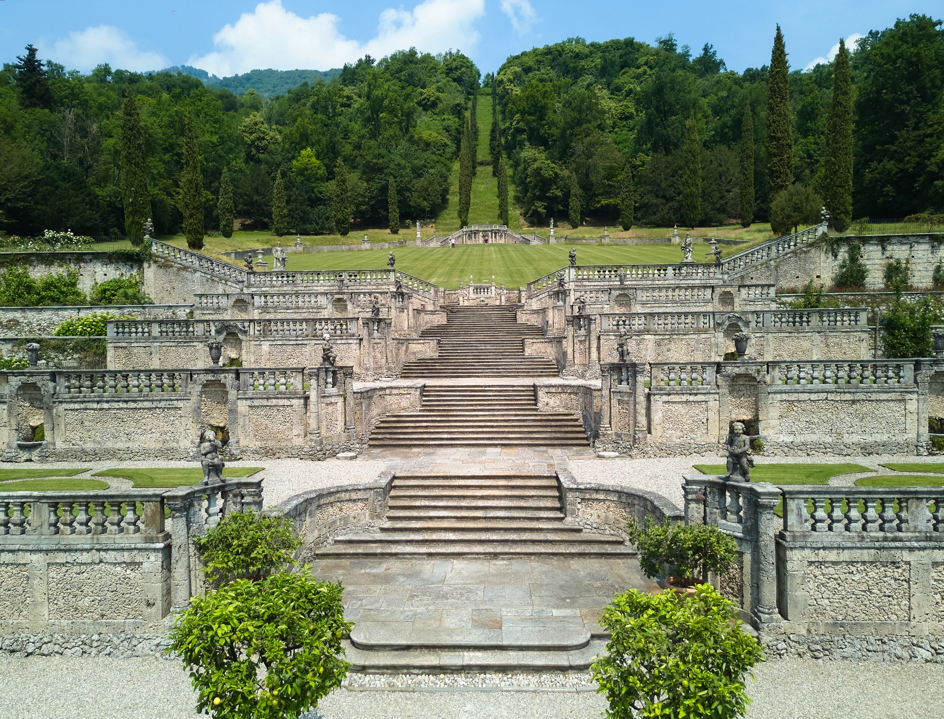
The fraction of ZuignoI develops around one of the symbolic places of the area:Villa Della Porta Bozzolo, a splendid FAI property. This sixteenth-century architectural jewel is embellished by Italian gardens on terraces and from a calendar full of cultural events, concerts and family activities.
A particularly significant aspect is the Free access to the park for Casalzuigno residents, which strengthens the bond between the local community and this extraordinary historical heritage, experienced not only as a tourist destination, but also as an integral part of everyday life.
The fraction of ArcumeggiaI is a real open-air museum, known as the"country of frescoes"The facades of the houses host works by famous Italian painters of the twentieth century, offering visitors an immersive experience among rural art and culture.
Thanks to the constant commitment of the municipal administration, Arcumeggia is today an unmissable destination for tourists, hikers and cyclistsThe recent opening of a kiosk equipped for hospitality has made the village even more welcoming and lively, ideal for a break surrounded by nature and beauty.
To enrich the cultural offering, within the village of Arcumeggia, there is the "Sangalleria",interesting fusion between an art gallery and photographic museum.A testament to the similar past and a visual memory of the place. Founded in 2005 by Luigi Sangalli and Flavio Moneta at Vicolo Malcotti 1, it has become a hub for events, exhibitions, and cultural projects related to fine art photography and the local artistic landscape.
During the summer, however,the party area on Via Sciareda becomes one of the main meeting points of Valcuvia. Surrounded by greenery and easily accessible, it hosts the most awaited food festivals of the season, which liven up the weekends from June to September and attract every year hundreds of visitors, not only from neighboring countries, but also from Varese and the Canton of Ticino.
These festivals represent a virtuous model of territorial valorization, where tradition, participation and community spirit join together to offer authentic and inclusive experiences.
Casalzuigno is much more than a hilltop village: it is a place where the sun goes hand in hand with history, where art coexists with nature, and where traditions are renewed through events, hospitality and local identity.A village to visit, but above all to experience.
Website: https://www.comune.casalzuigno.va.it/

CASSANO VALCUVIA
On the slopes of Mount San Martino, just above the state road that connects Cittiglio with Luino, there is Cassano Valcuvia: a village of 639 inhabitants, with a surface area of just under 4 square kilometers, which is also considered the "gateway to Valcuvia".
The name of the town already appears in various documents from the medieval period, from which the presence of a castle or castrum emerges. Cassano belonged to the county of Seprium and was a fief of the Visconti, and then followed the fate of all the towns in the valley. It was first part of the parish of Cuvio and, later, in 1675, it was erected as a parish, with the church dedicated to Saints Ippolito and Cassiano.
The name of Cassano, which probably originates from the noble Cassius, was added to that of Valcuvia after the unification of Italy, to distinguish it from other towns with the same name.
On the hill of San Giuseppe stands the homonymous Hermitage of the 11th century, among the oldest sacred buildings of Valcuvia. In the area surrounding the church, you can also visit the fortified redoubt of the Cadorna Line.
In the town centre, there is the Northern Frontier Documentation Centre Linea Cadorna, with six exhibition rooms dedicated to the defence line, the events of the Battle of San Martino during the Resistance and the environmental context of Valcuvia.
In the Town Hall you can visit the characteristic Art Nouveau theatre from the beginning of the last century, which still hosts theatrical performances and the local company Teatro Periferico.
Immersed in a suggestive natural context, Cassano Valcuvia is a good starting point for excursions along the rich network of paths, well marked and maintained, that from there unravel in the valley. The tranquility, the hilly landscape and the lively cultural activity make it an attractive destination for slow and sustainable tourism.
Illustrious figures of the town are Attilio De Tomasi, a famous fresco painter in the churches of France who worked in the parish church of Saints Ippolito and Cassiano, later restored by Frediano Berti. His brother, Pietro De Tomasi, a sculptor, dedicated himself to funerary art.
Although they are not natives of Cassano, Aldo Bertocci, tenor at the Scala in Milan, Ambrogio Fogar, explorer, navigator and writer, and Rinaldo Gallivaggi, a singular character known in the news for his alleged belonging to the Savoy family, have been linked to the town.
Website: https://www.comune.cassanovalcuvia.va.it/hh/index.php


CASTELLO CABIAGLIO
Castello Cabiaglio (Cabièj in Varese dialect), located in Valcuvia, in the Campo dei Fiori Park, is a characteristic village of around 560 inhabitants, nestled on the southern slope of Mount Martinello.
Reaching the village is quite simple: just take the provincial road from Brinzio that crosses the northern slopes of the Campo dei Fiori massif towards Cuveglio. The slightly winding but pleasant route winds through enchanting beech and chestnut forests, captivating in every season. The emerald green of spring, the cool shade of summer heat, the autumnal palette of treetops, and the white foliage of winter provide the backdrop to the village, which only appears around the last bend.
Surrounded by greenery, in a secluded, almost hidden location, it was a refuge for shepherds and mountaineers who fled from major roads to escape raiders devoted to plunder and violence. From the 16th century onwards, the town experienced a prosperous period of artistic and industrial development.
In the northern part of the territory, some terraces remain, historically used for agricultural cultivation and vineyards, but then progressively abandoned and invaded by forest.
The architecture of the houses, rich in portals, loggias, stuccoes and frescoes, remains a witness to its ancient splendor.
The ceramic factories, the various lime kilns and the silk mills of the past are proof of k the ingenuity of the old inhabitants.
The toponym derives from the characteristics of the town which, due to its position in medieval times, was identified as "CASTRUM VALLIS".'Castrum'is a term which translates into the word 'military camp' and which remains in the current language as the root of the word 'castle'; 'Vallis' corresponds to our 'della Valle' and could be translated as the adjacent "valley castle" (i.e. Valcuvia).This name has been gradually simplified over time, becoming Ca' Vallis (or "Viallis"), then Ca' biallis, then Cabialij (or "Cabialy"), and finally Cabiaglio.
Castello Cabiaglio preserves a rich historical and artistic heritage: the historic center preserves the typical architecture of the rural villages of the Alto Varesotto area, with stone houses connected by covered entrances, narrow porticoed streets and cobbled streets, and buildings dating back to the 15th century, some of which are frescoed.
The Baroque parish church of Sant'Appiano, dating back to the 12th century and enlarged in the 17th century, houses frescoes by Giovanni Battista Ronchelli (born in Cabiaglio in 1715) and an ancient organ dating back to 1701. The church of San Carlo, built in the first half of the 17th century, preserves a wooden altar and a 1646 canvas by Miradori depicting the Madonna and Child with Saints. To the north of the village rises Mount Martinello (619 meters), whose summit offers an excellent panoramic view of the Valcuvia valley, Verbano, and the Borromean Islands. On the slopes of this mountain, a staircase flanked by niches of the Stations of the Cross painted by Paolo Petter, a local artist, leads to the church known as the Oratory of the Blessed Virgin.
Another place of worship is the chapel of San Rocco, almost certainly built following the numerous plagues that struck the Cuvia Valley in the 17th century. During epidemics, lazarettos were built where the sick were taken to die, and at the end of each epidemic, a church or chapel was erected dedicated to San Rocco, considered the protector against the plague. San Rocco, who is thought to have died between 1360 and 1370 (or in 1195 in Montpellier, according to some sources), dedicated his life to helping plague victims and died in prison in Angera.
The buildings that can still be seen in the town, even if modified and renovated over time, help us understand how strategically important this place was in the past.
Until a few decades ago, as documented by some rare postcards from the 1920s, at the western entrance to the town there was a noble arch featuring a frieze, which showed the signs of the supports used to close the entrance at sunset.The column incorporated into the corner of the building is the only remaining part. This, along with other arches still standing on Via San Rocco and Via Asilo, served as a gateway to the village, which was closed at night to ensure safety from potential gangs of criminals.
The oldest houses, some connected to each other and others separated by dark, covered passages, with very thick walls made of squared stones, tell us that this area needed defense, because it was close to border territories subject to invasion by armies from Northern Europe, heading towards the Lombardy plain.
These simple old buildings create a stark contrast with the 16th-century homes and the most elegant ones, which demonstrate the wealth and prestige of their owners. Indeed, Cabiaglio had many patrician families, now almost all extinct.
The buildings are closely packed together, with underpasses and narrow streets, demonstrating the importance of always being ready to defend against potential external attacks. It's not hard to imagine that the highest point of Mount Martinello was used as a lookout, in constant visual communication with other fortresses, towers, and castles in the area, such as the tower of Pieve di Canonica, the tower of Mesenzana, the Arx media of Arcumeggia, the Rocca di Orino, the castle of Brinzio, and others.
In Cabiaglio was born on February 1st, 1715, the artist Gian Battista Ronchelli, son of Giacomo Antonio, a wealthy merchant, and Maria Grazia Porrani, daughter of the painter and architect Antonio Maria, and where he later died at the age of 73 on January 24th 1788.
From Giovanni Battista Giovio, Ronchelli's patron and his first biographer, we learn that at a young age he was trained as a merchant and settled in L'Aquila, where his family had been running profitable businesses for several generations, while studying "humanities." He remained there until 1733-34, when, disregarding his family's expectations, he moved to Rome to study painting in the workshop of the painter Francesco Mancini.
From the same testimony we learn that upon his return to Varese, towards the mid-18th century, Ronchelli continued his training under the guidance of Pietro Antonio Magatti, establishing a relationship of learning and collaboration destined to continue over time and to leave an indelible mark on the continuation of his artistic career.
In Cabiaglio, he enriched the church with fine paintings that can still be admired today, such as the main altarpiece and the medallions in the choir depicting the Sacrifice of Isaac and the Sacrifice of Melchizedek. In the village, he employed several students, whom he trained in painting, wood carving, and decoration.
The Salvini brothers carried out the stucco work and collaborated with Paolo Mambrini and Paolo Peter on the stucco and color decoration of the vaults and walls.
Among the notable men of letters of our time we can mention the Italian journalist and writer Pier Vittorio Buffa (Rome, 3 August 1952) who has emotional ties to this town where he spent most of his holidays and where he set his novel entitled "La Casa dell'Uva Fragola" which, by recounting the events linked to his family, retraces the events of the Great War.


CASTELVECCANA
The name and history of Castelveccana are linked to the castle that once stood on the Rocca promontory. In 963, despite the tenacious defense by the sons of Berengario II, the last feudal king of Italy, it was besieged, conquered, and burned by Otto I of Germany.
Once rebuilt, its military importance increased under the supremacy of the Visconti, Rusca, and Borromeo families, but it was finally destroyed by the Swiss in 1513. Unfortunately, only a few ruins remain of the castle, but valuable traces of its historic past remain in several sacred buildings: the Romanesque church of San Giorgio, the parish church of San Pietro, the bell tower of San Martino, the hermitage of Sant'Antonio (dating back to the 11th and 12th centuries), and the 15th-century sanctuary of Santa Veronica, exquisitely frescoed and built in a beautiful panoramic position on the Rocca. After the destruction of the castle, the Rocca di Caldé remained famous for its highly prized lime that was extracted and processed in the characteristic kilns, now disused but still clearly visible.
The name "Castelveccana" was born in 1928 from the administrative merger of the pre-existing municipalities of "Castello Valtravaglia" on the lake and "Veccana" upstream, but it is often more easily referred to by the short name of its lakeside hamlet "Caldé" and by some for its particularities: "the Portofino of Lake Maggiore".
Divided into several hamlets scattered throughout the wide Valtravaglia valley, the town extends between the Lombard shore of Lake Maggiore and the green mountains that separate it from the Valcuvia.
The gentle landscape, mild climate, and almost Mediterranean coastal vegetation coexist with the dense forests of centuries-old chestnut and beech trees of the Alpine foothills. The tranquility, clean air, unspoiled nature, and the opportunity to enjoy a variety of sports, especially water sports, and relaxing walks in the surrounding mountains, make Castelveccana a highly sought-after destination for leisure and vacation.
One of the main meeting places is the welcoming little square of Caldé, the small lakeside village that Piero Chiara defined as "the most charming, most spectacular and at the same time most peaceful, most intimate and most unspoiled spot on the entire coast".
The oldest part of the town is almost intact and gives us a glimpse of the small fishing and lime quarrying village as it was in the past.
From every point in Castelveccana—but especially from the evocative balcony of Santa Veronica, which looks out from the cliffs of the Rocca above the historic furnaces—you can contemplate one of the most vast and beautiful views of Lake Maggiore, framed by the majestic amphitheater of the Alps.
If Caldé is the coastal district of Castelveccana, the highest one is Sarigo, which is also the best-preserved rural corner of Valtravaglia. Half-hidden among ancient woods and vegetable gardens, Sarigo is a harmonious cluster of ancient stone houses, some dating back to the 16th century, graced with porticoes and balconies and joined by deep arches that span the winding streets.
Due to its natural beauty, its environmental characteristics, its lake, and the ancient villages scattered throughout the area, Castelveccana is rightly considered a place of tourist interest, but also a place of residence equipped with public services that enhance the quality of life even in a small town.
Sito web: https://www.comune.castelveccana.va.it/


CITTIGLIO
The town of Cittiglio, at 254 m above sea level, is located in the verdant Valcuvia area, nestled between mountains and meadows rich in native flora and fauna. It is divided into six historic hamlets, called Rioni: Cascine, Fracce, Cittiglio Alto, Valcuvia, Vignola San Biagio and San Giulio, to which are added the Pozzit and the mountainous Vararo, for a total of approximately 3830 inhabitants.
Its origins date back to the medieval era, when it was called Cistellum and stood on a small fortified hill on which were located a monastery and a church, which is now the church of San Biagio, a place of high architectural and historical value thanks to the archaeological finds of the last decade dating back to the Middle Ages.
Cittiglio is crossed by a cycle path and is full of very beautiful green areas such as the waterfall park, currently closed to the public for safety works, and paths that can be explored both on foot and by bicycle, such as the ring that from Pozzit reaches the Rione Cascine or the old mule tracks that go up to Vararo.
The train station also hosts a museum dedicated to its cycling champion Alfredo Binda, while the tour of historic wash houses called "La via dell'acqua" is under construction. In the village there is also the house where Giuseppe Garibaldi was a guest during the Mille campaign.
In addition to the champion Alfredo Binda and his brother Albino, Cittiglio has hosted numerous figures linked to the world of culture: the sculptor Luigi Broggini, who invented the six-legged dog, the historic logo of Agip; the painter Rosa Maria Stuani Nitais, who has won many awards in the figurative and landscape fields; Professor Luigi Violini, inventor of the Municipality's logo; the famous concert pianist Annita Porrini; Gianfranco Caporali, the carpenter who created a wooden sidecar used in a film by Renato Pozzetto; the painter and professor Vincenzo Morlotti; the jazz musician Paolo Paliaga; the journalists and writers Massimo Cassani and Felice Magnani; the writer Serena Contini.
Sito web: https://www.comune.cittiglio.va.it/


COCQUIO TREVISAGO
Situated between the lakes of Varese and Maggiore, southwest of the Campo dei Fiori massif and crossed by the Bardello stream, Cocquio Trevisago is a municipality of approximately 4,650 inhabitants.
The territory, rich in vegetation and paths, extends from the valley floor to the peak of Forte di Orino (1134 m above sea level), part of the historic Cadorna Line.
The first part of the name, Cocquio, derives from the Latin vulgar cock(small hill) - later cocquium for correction, word of Gallic origin- or from the name of the family of the local counts Coco; Trevisago, instead, derives from the Latin Tres vias agere underlining its being the meeting point of the three routes that led to Milan, Lake Maggiore and Switzerland.
Born in 1927 from the union of the villages of Cocquio and Trevisago, the town preserves traces of a thousand-year-old past, starting from the medieval tower located in the hamlet of the same name which, at that time, was a key point for the passage of information between the Adamoli fortresses of Besozzo and the Bastiani on San Clemente.In the Middle Ages, in fact, Trevisagoit housed the troops' quarters and, together with Cerro and Caldana, carried out an important military defensive function.
In addition to this building,of which now remains a ruin, even vbg98ijjiethe seventeenth-century villas and churches, the SOMS Theatre built in the early twentieth century and the church of the Purification with a Romanesque bell tower from the thirteenth century bear witness to an important historical and cultural heritage.
The urban development of the town has historically been divided into distinct urban nuclei, involving, in addition to the centre of Cocquio, the hamlets of Sant'Andrea, Torre, Caldana and Cerro.These last two are less affected by recent urbanization, they offer authentic views with valuable and well-preserved historic buildings.
Among the prominent personalities linked to the country, there is certainly the painter Innocente Salvini who was born and raised in a peasant family that ran a mill on the Viganella stream: warm colors, family members and moments of peasant life are in fact the characteristics of his paintings, collected in the museum created after his death next to the mill. Others can be found in the parish church of S. Andrea and in a fresco in the village of Arcumeggia.
Another well-known figure is Esteban Canal, born in Peru in 1896. He moved to Europe at the age of 16. Having become a chess champion, in the post-war period he settled in Italy, where he obtained notable results and victories in the chess field. He spent the last years of his life in Cocquio Trevisago, where he died in 1981.
The most famous character from Cocquio, however, belongs to the world of fashion: the stylist Fernanda Gattinoni. Born in Cocquio Trevisago in 1907, she had great success working both in Italy and abroad, where she was much loved, and also dressing movie stars such as Audrey Hepburn and Anna Magnani.
Today Cocquio Trevisago combines tradition and nature, thanks also to the cycle paths that connect it to Lake Varese and Lake Maggiore and to paths, such as the sculpture path in Cerro, with works of art created by Sergio Terni, which invite you to discover these places.
Website: www.comune.cocquio-trevisago.va.it
Facebook https://www.facebook.com/share/PcNYcwuwKWFFjbZE/


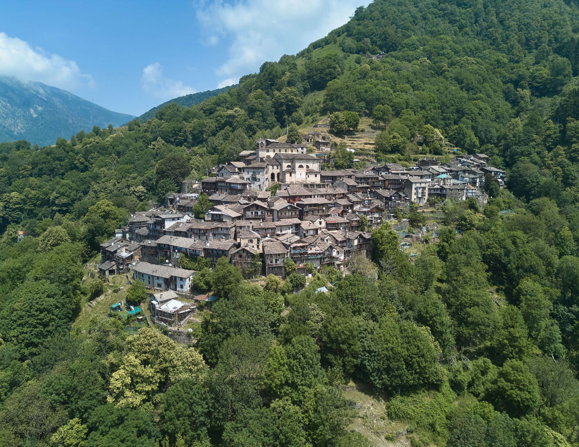
CURIGLIA CON MONTEVIASCO
Curiglia with Monteviasco is a municipality of 189 inhabitants,the only center of the Val Veddasca located on the southern slope.
The village is perched on the mountainside and is characterised by rustic exposed stone buildings and beole roofs.
Curiglia con Monteviasco is divided into two nuclei, still today connected not by a road, but by the mule track of about 1400 steps which constitutes the only access route to the village of Monteviasco waiting for the reopening of the cable car which connects the village to Piero's Bridge.
Monteviasco, now inhabited by a dozen people, is almost entirely made up of buildings with dry stone walls, often featuring "lobbie." Narrow cobbled streets intersect between covered passages and tiny open spaces, and the entire town centers around the large church dedicated to Saints Martin and Barnabas.
The great castle is also an interesting historical destination.Piero's boulder, near the homonymous location, near the Giona stream, which features numerous carvings of figures and symbols related to pagan worship, later replaced with "flowered crosses" around the 10th-11th century. Some of the carvings on this boulder, compared with others located a certain distance from the town, would suggest that the first settlements date back to 2000 BC.
Interesting are also Sarona and Alpone mountain pastures, located along the pedestrian path that leads to the Mount Lema and Mount Tamaro, once used for the transhumance of livestock and today fantastic oases of peace and nature.
Website: https://www.comune.curigliaconmonteviasco.va.it/

CUVEGLIO
Cuveglio is located in the center of Valcuvia, halfway between Luino and Laveno Mombello. It has a surface area of 7.67 square kilometers and is located at an altitude of 294 m.a.s.l. Composed of the hamlets of Vergobbio, Canonica and Cavona, it has a population of about 3,400 inhabitants.
Some archaeological discoveries have confirmed that Cuveglio was a centre of significant importance in Roman times, even if the first inhabitants were pile-dwellers who, with the retreat of the waters of the ancient glacial lake, took refuge in the "Coviglio" founding the first urban centre.
At the northern end of the town, in front of the promontory of Santa Maria, there was an ancient pagan cemetery dating back to before the Roman era. In 1911, during the construction of the provincial road, several tombs were also found, but later they were lost.
In 1949, Doctor Giuseppe Rigoli spoke of the discovery of numerous cinerary vases in the locality of "Chioso di San Lorenzo" with some coins that the Numismatic Cabinet had dated to the time of the Emperor Trajan, around 120 AD. These discoveries demonstrate that the town had assumed a certain vastness and that, therefore, its origin must have been remote.
In addition to several frescoes in the various hamlets, among the sacred buildings you can visit the church of Sant'Anna (14th century) with the chapels of the Via Crucis located at the start of the "brevissima" towards Duno and San Martino. The Santa Casa in Cavona, on the other hand,there is a sanctuary that is based on the one in Loreto.
The civic tower, next to the church of San Lorenzo, is another emblem of the historical importance of the town, while the church of Santa Maria, with the lazaretto, further testifies that, even before the Middle Ages, the valley was alive. Some frescoes of the church are now visible in the town hall, while other finds are in the historical museum of Varese.
Another unique place in the area (as well as unique in Italy) is theThe American Southwest Museum) which is located in Cavona and, every year, welcomes numerous visitors.
Website: www.comune.cuveglio.va.it


CUVIO
Cuvio is a municipality in Valcuvia that extends over a territory of 5.96 square kilometers and at an altitude of 309 m above sea level. With its hamlet of Comacchio, it has just over 1600 inhabitants.
Capo di pieve is mentioned in the Statutes of the roads and waters of the county of Milan (1346). With the entire Valcuvia it was enfeoffed in 1450 to the Cotta family, while in 1727 it passed to Count Giulio Visconti Borromeo Arese and then to the Litta Arese family. The historic Cotta and Visconti Borromeo Arese families lived from 1600 to 1800 in the fortress-palace, later converted into a stately home, which stands out with its tower in the main square. The gonfalon of Cuvio remembers them with the white tunic (or cotta) and the Visconti snake.
Subsequently, the town experienced various aggregations and dissolutions with neighbouring centres: with Napoleon in 1809, with the Lombard-Venetian Kingdom in 1815 and with fascism in 1928, but always with Cuvio as the historical centre.
Since the post-war period, it has returned to its original riverbed which, from the valley floor, rises up to Campo dei Fiori, crossed by the Boesio torrent (with the name of Broveda at its source) and with a characteristic area of irrigation ditches, waterfalls, small lakes and a Roman bridge inside the "English valley" – whose name has nothing to do with the inhabitants of the Channel, since it derives from the Latin "in glarea", meaning "on the gravel", due to the river which carried gravel and sand downstream.
Among the emblematic figures of Cuvio are: Virgilio Savini (c. 1850 - 1925), creator of the most renowned restaurant in the Galleria in Milan; Enrico Porro (1885 – 1967), with parents from Cuvio, winner of the first Italian gold medal at the 1908 London Olympics in Greco-Roman wrestling, lightweight category; Leopoldo Maggi (1840 – 1905), professor and luminary biologist, zoologist and geologist, descendant of the noble Milanese family who took refuge in Cuvio in the 19th century.
Piero Chiara, then, with his novel "Il pretore di Cuvio" made the courthouse famous. It existed there until 1929. The film "Venga a prendere il caffè... da noi", inspired by his novel "La spartizione", directed by Alberto Lattuada and starring Ugo Tognazzi, was filmed largely in Cuvio.
Mascioni Organi, founded by Giacomo Mascioni in 1829 in Comacchio di Cuvio, is still an important organ manufacturing and restoration company worldwide.
Website: https://www.comune.cuvio.va.it/


DUMENZA
Dumenza is a village of about 1,500 inhabitants located in a large mountainous area just above Lake Maggiore, on the slopes of Mount Lema which, at 1,624 m above sea level, represents one of the most panoramic and highest peaks in the Luino area.
It is a peaceful town rich in history, artistic beauty, and natural beauty, offering a perfect balance of landscape, hospitality, and tranquility.
The territory is crossed by the Rio Colmegnino, which originates in the locality of Regordallo (Due Cossani) on Mount Colmegnino. The valley formed by this watercourse is known as Val Dumentina, often also called "Emerald Valley"thanks to its green hues.
The natural landscape is characterized by silent forests, meadows, mountain pastures, clearings, waterfalls, picturesque slopes, and panoramic terraces overlooking Lake Maggiore. The mountain roads and paths recall ancient routes once traveled by smugglers who traded goods between Italy and Switzerland—a piece of history that lives on in the tales of the elders.
In Dumenza there are several hamlets, each with its own historical, artistic and landscape peculiarities:Torbera, Dumenza, Trezzino, Runo, Stivigliano, Due Cossani, Vignone, Pradecolo and Pragaletto.
The town gathers around its numerous churches, including the parish church dedicated to Saint Georgeto Runo, the Church of St. Elizabeth in Due Cossani, the Church of Saints Nazario and Celso and theChurch of the Immaculate Conceptionin the center of Dumenza.
From the hamlet of Trezzino, a mule track marked by thirteen chapels of the Via Crucis takes the visitor to the Sanctuary of Trezzo, a very important place of devotion for the local community, dedicated to Santa Maria Assunta. In the Pragaletto area, climbing towards the summit of Lema, there is the monastery that houses the Monastic Community "Holy Trinity".
The oldest glimpses of the villages are characterized by narrow alleys, stone houses, frescoed walls, and charming courtyards, which tell a simple, rural tale, nestled beautifully alongside more modern streets, new homes, schools, and commercial and service businesses. The remains of long-abandoned mills, old mountain huts and farmhouses, former dairies, and, more recently, the remains of modern, now-abandoned factories, are still visible today.
The history of rural life is accompanied by a generous nature, Woods populated by foxes, ungulates, badgers, squirrels, and hares; flower-filled slopes; waterways inhabited by amphibians and fish; spaces overflown by birds such as hawks, blackbirds, woodpeckers, and passerines. It is an ideal area for those seeking hikes, walks, or moments of pure contemplation, with the opportunity to rest and warm yourself at mountain huts, restaurants, bars, and farms, as well as to find rest in welcoming and intimate accommodations.
In Dumenza there is also an important meeting place, the Center Carà,a popular municipal park that hosts numerous local musical, sporting, and cultural events, as well as events of importance for the surrounding area. Local associations and groups, working alongside the municipal administration, work to promote the area by organizing various events.
Dumenza is often remembered as the birthplace of famous and historically significant figures. Among them are: Bernardino Scapi, known as Bernardino Luini, Renaissance painter related to the Leonardo school whose works are now preserved in many churches and museums;Bartolomeo Scappi, the greatest Italian chef of the sixteenth century who served at the court of two popes, Pius IV and Pius V, and who in 1570 collected his knowledge in a monumental gastronomic treatise entitled "Opera";Raffaele Casnedi, nineteenth-century painter and professor at the Brera Academy, considered one of the representatives of Romanticism and Realism in the nineteenth century;Vincenzo Pietro Peruggia, Italian decorator known for having stolen Leonardo da Vinci's Mona Lisa in 1911 from the Louvre Museum in Paris, causing great international outcry.
Dumenza is the perfect destination for those seeking a slow-paced experience, away from the mass tourism, ideal for family excursions, trekking, gastronomic experiences, and immersion in the history of a fascinating Alpine border.
Website: https://www.comune.dumenza.va.it/


DUNO
With approximately 160 inhabitants and a location at 530 meters above sea level, Duno is one of the smallest and most charming municipalities in the province of Varese. Surrounded by greenery and rich in historical sites, it is an ideal place for those seeking tranquility, scenic beauty, and off-the-beaten-path itineraries.
Nature is the protagonist, with chestnut groves, erratic bouldersand paths that wind through the woods. The area of the"Faggio del Gelato", a centuries-old tree located along the trail to Monte San Martino, owes its name to the tradition, dating back to the 1930s, of ice cream vendors stopping here during the feast of San Bartolomeo.
Among the traces of the rural past we find wash houses, ancient watering troughs of the Cadorna Line, and the remains of old mills in the Costaccia area. Near the Alpe di Bis, you can also observe mysterious rock carvings.
The historic center preserves "Ur Fort", a building that is thought to have stood on an ancient fortification. This detail is linked to the origin of the name "Duno," which derives from the Gallic term Dunum, meaning "fortress" or "fortified hill".
Among the places of cultural interest stand out the Parish Church of Saints Julian and Basilissa, which preserves some relics, and the Votive temple of the doctors of Italy, symbol of devotion and memory.
Duno also hosts an original open-air museum .Along the streets of the town there are frescoes, sculptures and bas-reliefs created in 2012 by doctor-artists or in collaboration with doctors, all dedicated to the theme "Health in medical thought".
Numerous paths and mule tracks connect Duno to Arcumeggia, Monte San Martino, and other nearby locations, making it an ideal starting point for exploring history and nature on foot or by mountain bike.
Website: https://www.comune.duno.va.it/

FERRERA DI VARESE
The Municipality of Ferrera di Varese is one of the smallest in the north of the Province, with its 1.61 square kilometers. However, it has some peculiarities that attract many visitors, especially in the summer.
The main one is certainly the Ferrera waterfall, also known as the "Fermona" waterfall: a natural monument of great value located within a particular naturalistic context.The Margorabbia torrent jump, 30 metres high and a place of cool refreshment much appreciated during the summer season, is easily reachable from the town centre by following the cycle path that ensures an easy connection to Luino and Valcuvia. In addition to this, you can also admire two other smaller waterfalls, one closer to the town, and one that flows directly from the rock.
The town, at an altitude of 298 m.a.s.l., is surrounded by thick vegetation. Also worth a visit is the monument to the Fallen in the Rocca area, from which you can enjoy a wide view of the town and the valley.


GAVIRATE
Overlooking Lake Varese, Gavirate is a town rich in history, nature, and art.
Its origins date back to the 7th millennium BC, as evidenced by the pile-dwelling finds along the lake shores. First inhabited by the Gauls and then conquered by the Romans, Gavirate has experienced the influence of various dominions over the centuries: Lombards, Benedictine monks, Spanish, and Austrians. The village also played an active role in the Napoleonic reforms and the subsequent structure of the Kingdom of Lombardy-Venetia, with the establishment of the first City Council in 1824.
Its historical heritage includes the charming hamlet of Voltorre, home to the ancient medieval cloister founded between 1100 and 1150 by the monks of the Abbey of Fruttuaria, now a national monument. Also worth a visit is the parish church of San Giovanni Evangelista, which houses a prized organ built in 1901 by Vincenzo Mascioni.
The center also hosts places of culture and relaxation such as the civic library, located in the renovated Villa De Ambrosis, and Morselli Park, donated by the writer Guido Morselli: a green area with playgrounds, paths, and a breathtaking panoramic view of the Alps and Lake Varese.
Gavirate is also home to a unique museum in Italy: "Il Museo della Pipa", founded by Alberto Paronelli in the late 1970s. Housed in a rustic 19th-century house, the museum houses over 30,000 pieces, including historic pipes, utensils, antique volumes, and rare objects from around the world, including pre-Columbian pipes, hookahs, meerschaum pipes, and German porcelain.
Finally, Gavirate's commercial tradition is evidenced by the weekly Friday market, established in 1539 by order of Charles V.


GEMONIO
Gemonio is a town of about 2,900 inhabitants located on a hill at the entrance to the Valcuvia valley, with a beautiful historic center.
In its territory you can undoubtedly admire the church of San Pietro dating back to the 7th-8th century, in Lombard Romanesque style, embellished with frescoes and a pre-Romanesque altar.
The Floriano Bodini Civic Museum, housed in a restored farmhouse, houses the works of the sculptor of Gemonio origin, who grew up in Milan and was a driving force behind "existential realism."
The Parish Church of San Rocco and Beata Vergine Addolorata houses the wooden altar of San Pietro and the triptych of Madonna Addolorata, both works by Bernardino Castelli, the early 20th-century Mascioni organ, and paintings by the painter Innocente Salvini.
Also of great artistic value is the mural by Andrea "Ravo" Mattoni, "Il suonatore di liuto," inspired by the work of Caravaggio, made at the E.Curti Primary School.
Website: https://www.comune.gemonio.va.it/


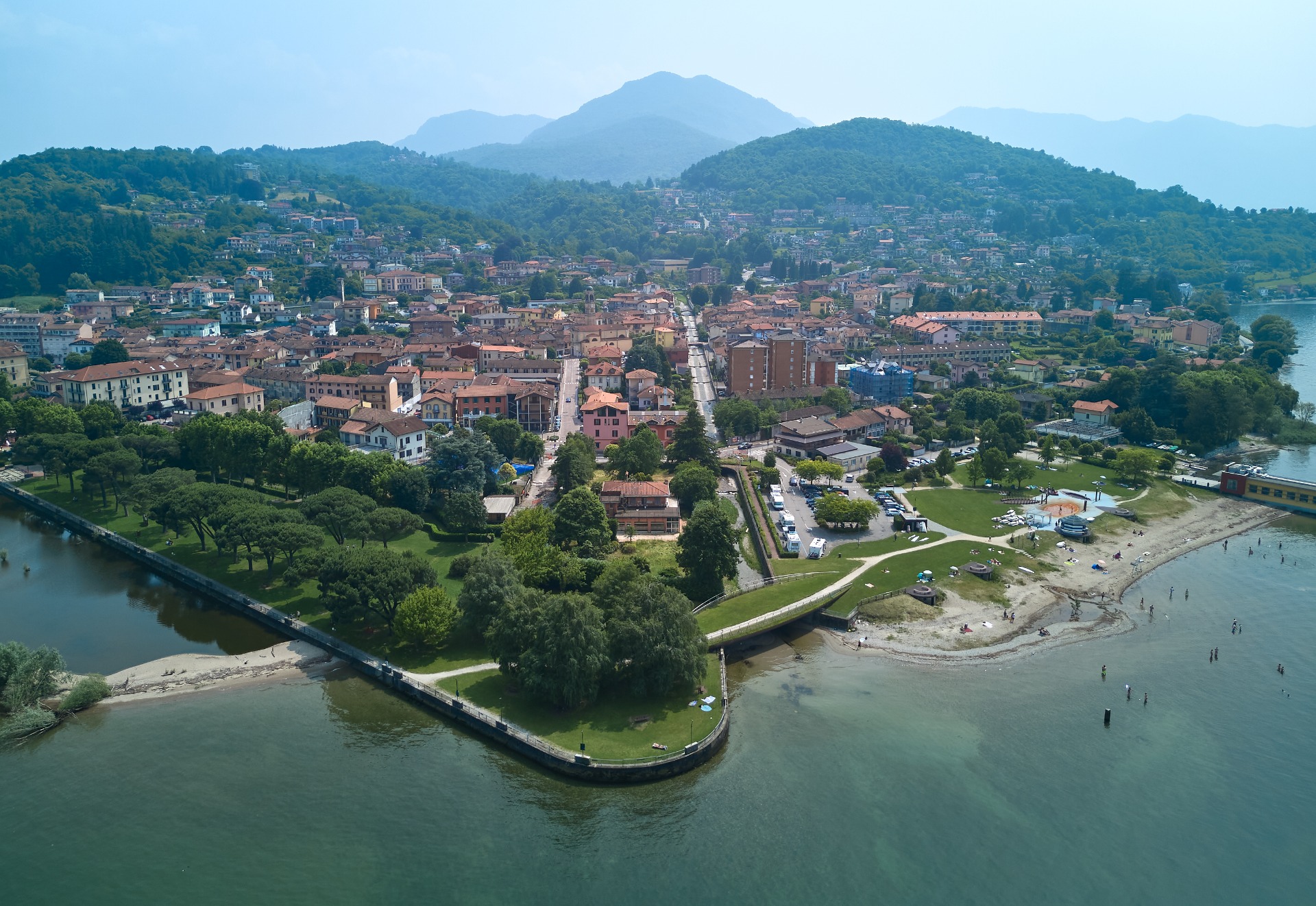
GERMIGNAGA
Overlooking Lake Maggiore, Germignaga is a village of ancient origins, nestled between the Tresa River, the Margorabbia stream, and the San Giovanni, three waterways that have shaped its territory and history.
The historic heart of Germignaga, with its cobbled streets and set back from the shore, tells of a town inhabited since pre-Roman times, as evidenced by pile-dwelling finds from the Stone and Bronze Ages. Its first documentary mention dates back to 807, but it was between the Middle Ages and the Renaissance that Germignaga played a central role in the valley, with its own fortress and a thriving trade in timber, wine, and fish.
In the twentieth century, after a brief and controversial annexation to the Municipality of Luino during the fascist regime, the town regained its autonomy in 1947 thanks to the will of the citizens.
Today, Germignaga is a welcoming, green destination. The Boschetto Park, at the mouth of the Tresa River, offers a shaded area among pines and hornbeams.Just a few steps away is Le Fontanelle Park, with water features and a view of the lake. You cannot miss the Bosco delle Fate, an enchanted path that leads to Brezzo di Bedero.
The architectural symbol of the town is the former heliotherapy colony known as "Bislunga," a building overlooking the lake shaped like a ship, now restored and returned to the community. Also of particular interest are the churches of Saints John Baptist and Rocco, and the ancient and evocative church of San Giovanni, located near the cemetery.
Website: https://www.comune.germignaga.va.it/it-it/home

GRANTOLA
Grantola is located in the most southern part of the Valtravaglia, where the Valcuvia ends. The Grantorella stream, on whose banks the oldest part of the town arose, flows through the town, and extends until it reaches the Margorabbia stream.
An autonomous municipality until 1927, when the general revision of the municipal districts desired by the fascist government incorporated it into those of Montegrino and Bosco Valtravaglia, it regained its autonomy in 1957.
The area has approximately 1228 inhabitants, who are called Grantolesi but, within that ancient tradition of mockery among the villages in the valley,they are nicknamed "Maran".
The name Grantola, attested as Grantora in the 13th century, has its origins in the compound of the late Indo-European terms*grant(land) and*olâ(push in one direction), transformed into*grantolâin Celtic times, therefore translatable as "fold of the ground".
The church of San Pietro, dating back to the 11th century, houses frescoes of considerable value, among which the altarpiece depicting the Madonna del Buon Consiglio, created in Byzantine style in the 16th century.
The church of San Carlo, on the other hand, was built in the 17th century at the behest of Cardinal Borromeo based on a design by Richini and deconsecrated in 1965. The interior is devoid of furnishings and ornaments, which were moved to the new parish church of Saints Peter and Paul. Today, the church, purchased by the municipality, hosts cultural events and activities.
Palazzo De Nicola, built in the 17th century and subsequently renovated, features Masonic symbols and a depiction of the Stephenson locomotive on its exterior façade, a testament to Gaspare De Nicola's 19th-century railway operations in Italy and Portugal. Maybe the palace was built on the ruins of a previous structure destroyed by the Landsknechts in the 16th century. Within what was once the palace's park, connected to it by a pedestrian bridge, the "walls" are clearly visible, a neo-Gothic backdrop constructed between the late 19th and early 20th centuries on the banks of the Grantorella River.
Finally, overlooking the square that houses the old municipal washhouse is the ancient fresco of the "Madonna delle Nevi", dated November 17, 1618.
For trekking enthusiasts, Grantola offers cycle and pedestrian paths ideal for all types of excursions, allowing you to explore and discover hidden corners (like the Calderone waterfall) or more famous ones (like the Fermona waterfall).
For team sports enthusiasts, the municipal sports center is open to everyone. It opened in 2006 and is the result of a collaboration between the municipality and the parish. It is currently managed by the local Pro Loco.
Among the notable figures of the town was Maestro Quirino Besati (1884–1975): bandmaster and composer of band music, he was very active in the town, where he also served as a city councilor. He composed the brilliant march "Grantola," which over the years has become a sort of municipal anthem.
Maestro Giacomo Pierino Gandini, born in Grantola in 1912, was the first clarinet of the orchestra of the Municipal Casino of Sanremo, of the Teatro dell'Opera and of the RAI Symphony Orchestra of Rome.
Lawyer Alberto Dall'Ora, one of Italy's leading criminal lawyers who defended, among others, Vincenzo Muccioli and Enzo Tortora, purchased and renovated an old building in the center of Grantola, which became his summer residence, establishing a convivial relationship with the locals.
Finally, the singer-songwriter Biagio Antonacci who, as a boy, spent his summer holidays in Grantola with his family.
Website: https://www.comune.grantola.va.it/


LAVENO MOMBELLO
Laveno Mombello is a town rich in places of cultural, historical, artistic, and environmental interest that make it a must-see tourist destination.
Its gulf is a precious jewel overlooking the Borromean Islands, equipped with various moorings for boats, and protected from behind by mountains such as Sasso del Ferro, which offers one of the most panoramic points not only for tourists, but also for sports enthusiasts such as hang gliding and paragliding.
Divided into three villages – Laveno, Mombello and Cerro – this tourist resort has been a strategic point of many passages since the time of the Romans, from whose commander Titus Labienus the name of this town can be taken. Millennia later, it would witness some events linked to Garibaldi, who fought the Austrians here in 1859.
Each village has its own unique characteristics: Laveno, the heart of ancient ceramic production, extends along the entire coast, reaching the hamlet of Cerro, with its picturesque landscapes and beaches, while the hamlet of Mombello dominates the entire landscape from its hills.
Internationally, Laveno Mombello is known for its important production of ceramics and porcelain, the history of which can be traced thanks to the MIDeC-International Museum of Ceramic Design and the various testimonies still visible today, characterised by the world-renowned "Laveno blue" decoration.
Today, the area offers a welcoming tourist destination, offering a wide range of opportunities for everyone, residents and tourists, to enjoy cultural and outdoor activities in a unique and evocative setting, blending tradition and nature.
Website: https://www.comune.laveno.va.it/it
Facebook: https://www.facebook.com/Laveno.Mombello
Instagram: https://www.instagram.com/comunedilavenomombello/


LUINO
Luino, overlooking Lake Maggiore, is the largest city in the upper Verbano area, with approximately 14,000 inhabitants. Surrounded by green hills and enchanting views, it boasts an ancient and fascinating history.
Its origins date back to Roman times and its name appears for the first time in a document from 1169. However, it had long been an important transit and trade point thanks to its strategic position between Italy and Switzerland.
During the Middle Ages and the Renaissance, Luino was contested by various noble families and regional powers, passing from the Visconti to the Sforza until the Spanish domination. In the 19th century it was also an important center of the Italian Risorgimento, with Giuseppe Garibaldi who fought right here in 1848 during the Five Days of Milan, leaving an indelible mark on the city's memory. A statue just steps from the lake, erected during his lifetime, is dedicated to him.
During the 20th century, Luino experienced growth driven by the textile industry and tourism. Today, it is a lively and welcoming town, an ideal starting point for discovering the landscapes of the Valcuvia, Lake Maggiore, and the Swiss valleys. Its historic center tells ancient stories through its narrow streets, porticoes, and a vibrant, centuries-old weekly market—established by Charles V in 1541—which still attracts visitors and tourists from all over Europe every Wednesday.
Luino is also the birthplace of famous artists and preserves a 'genius loci' of which the writer Piero Chiara and the poet Vittorio Sereni are perhaps among the greatest representatives. Among those born in the city are also the comedians Massimo Boldi and Francesco Salvi.
Nature and culture, Luino is the ideal place for those seeking relaxation in an authentic, picture-perfect atmosphere. A corner of beauty waiting to be discovered, in every season.
Sito web: https://www.comune.luino.va.it/
Facebook: https://www.facebook.com/comunediluino
Instagram: https://www.instagram.com/infopointluino/


MACCAGNO CON PINO E VEDDASCA
Maccagno con Pino e Veddasca is a charming municipality in the Alto Verbano area, created in 2014 from the union of three historic communities: Maccagno, Pino sulla Sponda del Lago Maggiore, and Veddasca.
The area includes numerous hamlets and mountain villages, including Armio, Cadero, Garabiolo, Graglio, Lozzo, and Musignano, immersed in nature and rich in panoramic views, authentic atmospheres, and historical testimonies.
Maccagno, in particular, boasts a unique history: in 962, after hosting Emperor Otto I, it obtained the title of "curtis imperialis," enjoying administrative autonomy for centuries. This unique status led to the creation of two distinct centers, Maccagno Inferiore and Maccagno Superiore, separated by the Giona stream, which remained separate until the 20th century. Maccagno was also home to an imperial mint active in the 17th century, visible today in the Imperial Tower building.
Among the places of interest are the Parisi-Valle Civic Museum, overlooking the mouth of the Giona River and dedicated to contemporary art, and the church of San Materno.
The village of Cadero hosts an original Micro Museum that tells stories and legends related to the Mona Lisa, while the town streets are adorned with vibrant mosaics created by art students.
For outdoor enthusiasts, Lake Delio, located at 930 meters above sea level and surrounded by spectacular views of the surrounding lakes and mountains, and the Forcora Pass are definitely not to be missed. From here, you can set off on various hikes in the surrounding mountains, enjoy the views, and, in winter, even ski if there's snow.
Overlooking the coast of Lake Maggiore is also theCinzanino cliff, a reference point for sport climbing.
Official website of the organization: https://www.comune.maccagnoconpinoeveddasca.va.it/it
Facebook: https://www.facebook.com/profile.php?id=61572557860034
Instagram: https://www.instagram.com/comune_mpv/


MASCIAGO PRIMO
Masciago Primo, a small mountain village of ancient origins, is located in Valcuvia. Known locally as "Masciàgh," the town has fewer than 300 inhabitants and retains an authentic charm, thanks to a perfectly preserved historic center, with cobblestone streets and stone houses that tell the story of centuries of history. The name itself, of Celtic origin, means "country village with many pebbles."
The roots of the city date back to Roman times and spanned the Middle Ages as part of the Valcuvia fiefdom. A rare historical reference dates back to 1176, when a certain Montenario de Masciago is mentioned as a judge in the service of Emperor Frederick Barbarossa.
One of the jewels of the village is the church of Sant'Agnese, one of the oldest in the area, located in the southern part of the town. Built in the Middle Ages, it was restored in 1795 and then expanded several times in the 19th century. Inside, noteworthy features include a valuable painting on the high altar, an 1888 organ, and frescoes by Luigi Morgari. The church, now a Latin cross with three Lombard-style naves, was consecrated in 1941 after a major restoration in the last century. The remains of a fortress once stood next to it.Strolling through the historic center you can also admire a 19th-century mural fresco dedicated to Saint Anthony the Abbot.
Masciago Primo also stands out for its pristine nature. The municipal territory, largely wooded, boasts evocative sites such as travertine formations, waterfalls, natural gorges, and the erratic boulder known as"Sass della Rossera". There are traces of its military history, with remains of the Cadorna Line, testimony of the war period.


MESENZANA
Located in the verdant Margorabbia valley, a few kilometers from Luino, the village of Mesenzana boasts a rich historical and natural heritage. The symbol of the town is its medieval tower, an ancient vestige of the castle that once belonged to the noble family Da Mesenzana , administrators of the territory on behalf of the Lords of Milan since the 13th century.
Traces of a rich past resurface in the historic center and its surroundings: from the Valtravaglia statutes of 1283, which mention the maintenance of the castle, to the pastoral visits of Cardinal Federico Borromeo and the engineer Agostino Ramelli, born right here, famous for his inventions described in a work printed in 1588.
Mesenzana was also a site of ancient mining and smelting activities: in past centuries, the towns of Cavoi and Cavoiasca were inhabited by charcoal burners, and the entire area was involved in the extraction and processing of iron, facilitated by the presence of lush forests and natural resources.
For trekking enthusiasts, a must-see itinerary is the "Alpini dell'Intra" trail, which starts from the town center and reaches the charming abandoned village of Cavoiasca. Nestled in the woods, it preserves evocative stone remains: arches, cisterns, and agricultural terraces that tell a thousand-year history. From here, the trail continues to the fort of Vallalta , a fascinating panoramic point, through the trenches and emplacements of the Cadorna Line.
Also not to be missed is the parish church of the Purification of Santa Maria (1740), which houses a valuable 19th-century organ and a canvas attributed to the painter from Lugano Antonio Rusconi.
Website: https://www.comune.mesenzana.va.it/

MONTEGRINO VALTRAVAGLIA
The town of Montegrino Valtravaglia extends from the Margorabbia River to the slopes of Mount Sette Termini, made up of nine villages (Cucco, Riviera, Sorti, Bosco Valtravaglia, Castendallo, Sciorbagno, Montegrino, Ostino and Sciorbagno) as well as numerous other localities scattered across the large territory that comprises it.
Its history is not simple – enriched by conflicts between the abolished municipalities of Montegrino and Bosco Valtravaglia (which have undergone continuous mergers and dissolutions over the centuries) – it is rich in historical and artistic elements from the past, starting from the Masso Altare near the Bolle di Montegrino, passing through the frescoes by Guglielmo da Montegrino at the small church of San Martino, the numerous churches scattered throughout the area, in particular the small museum of sacred art at the church of the Annunciation in Bosco Valtravaglia and the famous nativity scene made of roots by Fermo Formentini.
There are traces of ancient, settled prehistoric populations who left signs of their presence in the form of rock carvings in Montegrino. The presence of the Romans in Bosco Valtravaglia is also attested, as evidenced by the discovery of coins and various objects during excavations; in particular, near the town, at the beginning of the last century, Roman tombs were discovered, along with a Byzantine coin of the Emperor Anastasius I (5th century AD).
The entire area is blessed with lush forests, natural environments such as Lake Montegrino, the peak of Mount Sette Termini, meadows and pastures, and numerous trails that lead tourists to the most beautiful and scenic villages and areas, with glimpses of Lake Maggiore and the Valcuvia Valley.
Within the territory, immersed in the woods are the famous military fortifications of the Northern Frontier, more commonly known as the Cadorna Line trenches, built during the First World War to defend the territory against a possible attack by Germany through Switzerland.
Among the most illustrious natives of Montegrino Valtravaglia is certainly the painter Giovanni Carnovali, known as "Il Piccio," born in Montegrino in 1804. He was one of the few Italian Romantic painters to transfer sentiment to canvas with authentic spontaneity, without indulging in imitations of contemporary pictorial trends, and can perhaps be considered the first of the Scapigliati.
Guglielmo da Montegrino, on the other hand, was a painter active in the valleys between the 15th and 16th centuries. His works, especially his depictions of faces, express an easily recognizable expressionist streak, often verging on the grotesque. His style is also characterized by a color palette that favors strong colors, juxtaposed for contrast. The language of his images is always stark and graphic, insistently emphasizing details of bodies and faces. In short, Guglielmo da Montegrino's art combines elements of tradition with Nordic expressionist influences, and he also likes folksy touches.
More recently, Massimo Antime Parietti was born in Bosco Valtravaglia in 1914. He was a renowned artist who never stopped experimenting, testing, and practicing, constantly renewing himself. Different periods are discernible in his work: one can discern the evolution of an artistic language that sought to express itself in ever-new forms, with works of impressionistic, realistic influences, and veins of chiaroscuro.
Not only are there artists from the area, but also the historian Marco Formentini, born in Bosco Valtravaglia, a passionate scholar of history and economics, who left behind numerous works, some of which are unpublished. He also dedicated himself to the history of his hometown, publishing statistical, historical, and biographical notes on the municipality of Bosco and its inhabitants (Milan 1856). A street in Milan between Via Brera and Via Mercato is also named after him.
Another illustrious figure was Dante Ughetti, born in Montegrino Valtravaglia in 1925. He graduated in the French Language and Literature at Bocconi University and was an assistant professor at the University of Padua, Verona branch. In addition to teaching, he devoted himself to his studies and scientific research. He was appointed to the Oriental University Institute of Naples, devoting his scholarly attention to François D'Amboise, Jean de La Taille, and Claude Henri de Saint-Simone, and finally became a tenured professor at the University of Naples, where he remained until October 31, 1977. He returned to the University of Padua, where he remained until his death.He had a marked talent for poetry.
The municipality of Montegrino Valtravaglia, despite being a small town, enjoys remarkable naturalistic, historical, and cultural wealth just a stone's throw from Varese and the magnificent Lake Maggiore.
Sito web: https://www.comune.montegrino-valtravaglia.va.it/


ORINO
Orino is a small village of about 850 inhabitants, nestled on the north-western slopes of the Campo dei Fiori massif, at 456 m above sea level. Here time passes slowly, between nature, history and tradition, offering an ideal environment for slow tourism: excursions, walks and relaxation immersed in greenery.
The heart of the town is Piazza XI Febbraio, where the Town Hall, the church of the Beata Vergine Immacolata (which houses a very valuable Mascioni organ) and the Orino Family Club are located.Also worth admiring is the Rocca, the imposing fortification of pre-Roman origin (3rd-4th century BC), once a strategic control point on the roads towards the Po Valley and Lake Maggiore. From the Rocca you can enjoy a spectacular view over the entire Valcuvia.
The Fonte Gesiola is instead an ancient source, documented since 1656 and restored in 1949. Here you can drink the fresh water from the spring and you can be guests of its "crotto" through a quiet walk from the center in the woods.
Another symbol of the town of Orino is undoubtedly the monumental lime tree that stands near the small church of San Lorenzo (14th century): a monumental tree over 170 years old to which the town is extremely attached due to its grandeur and historical-naturalistic value.Nearby there is a playground and a sports centre where you can eat and play soccer, tennis, basketball as well as bowls, surrounded by a green setting of rare beauty.
Nature and trekking lovers can enjoy path no. 2 (302) towards Pian delle Noci and Forte di Orino which starts from the centre of the town: 3 km long and with a difference in altitude of around 700 metres. It leads, through the thick chestnut, walnut and beech forest, to Pian delle Noci and then to Forte di Orino (1139 m) with panoramic views of great impact on Lake Varese, Lake Maggiore and the Rosa massif.
In addition to this, numerous other trails branch off from the town towards the neighbouring towns (Castello Cabiaglio, Cuvio, Caldana di Cocquio Trevisago) and the Campo dei Fiori massif, also ideal for mountain bikes.
In the area of the "Campo sportivo" in the Fugiana area there is also the Biodiversity Park, managed by the Matrioska association which looks after the educational orchard with the poppina apple - an ancient variety of native apple recently rediscovered and cultivated - and an ancient and valuable chestnut forest which, like the entire wooded area that surrounds the town, was once an essential resource for the local population who based their economy also on the collection and processing of chestnuts.
Website: https://comune.orino.va.it/hh/index.php
Further information, documents and testimonies are available on the website
https://www.orinosmartvillage.it/
Facebook: https://www.facebook.com/comune.orino
Instagram: https://www.instagram.com/comune.orino/


PORTO VALTRAVAGLIA
Porto ValtravagliaIt is a charming village on the Lombardy shore of Lake Maggiore, surrounded by water and mountains, which preserves a rich historical, artistic and naturalistic heritage.
Already a holiday resort in the 18th century, it has developed over time around two main centers: the capital Porto, on the lake, and the valley plateau.
Inhabited since the Iron Age, Porto Valtravaglia has witnessed centuries of history, spanning Roman, medieval, and modern eras. Important noble families, such as the Sessas and the Ruscas, have left traces of their presence. From the 17th century onward, the village was enriched with elegant stately homes along what is now Via Roma. The thriving glass industry, established in the 18th century, long fueled the local economy, with production praised even by Melchiorre Gioia.
Today, the town stands out for its picturesque lakeside promenade, picturesque hamlets such as Ligurno and Torre—dominated by a medieval tower—and numerous religious buildings of great artistic value. The hamlet of Domo preserves the oldest remains, including the Baptistery of San Giovanni Battista (before the 11th century) and the Romanesque Church of San Giorgio.
Porto Valtravaglia is also an ideal starting point for nature excursions, thanks to a hinterland rich in woods and scenic trails. One of the most popular spots is Alpe San Michele (822 m), a stone mountain village, now a summer destination, offering spectacular views of Lake Maggiore.


RANCIO VALCUVIA
Rancio Valcuvia is a town of about 900 inhabitants, composed of two inhabited centers: the main one of Rancio, at the foot of Sass Marée, and that of the hamlet of Cantevria, on the other side of the valley, on the slopes of Mount San Martino. The Rancina stream crosses the historic center and five bridges connect the two opposite banks.
The territory has a very irregular shape and significant differences in altitude from one locality to another: in fact, it goes from 280 m above sea level in the locality of Casone to around 500 m on the borders with Brinzio and Bedero.
According to some scholars, the origin of the name Rancio can be traced back to the word "ransc", or rancid, in reference to the humidity of the ground. Documentary traces of Rancio Valcuvia can be found around the year 1000, in notarial deeds, or in reference to ecclesiastical facts, but there is no direct information on the origin, life or even the shape of the settlement.
The hamlet of Cantevria is a small village that has always aimed at joining Rancio, as Giovanni Stefano Cotta sings in his poem about Valcuvia. Its name means, according to an unpublished study by the late Don Mario Frecchiami, a house or group of houses located near the water, with a clear reference to the swamp that until a few centuries ago covered the valley floor.
In the Middle Ages Rancio joined the Seprio Committee, then passed to the bishop of Como and ended up being subjected to the Milanese from 1196. In 1450 it passed under the fiefdom of the Cotta family and, three hundred years later, it became the property of the Visconti Borromeo and the Litta family.
In 1592 Rancio had four churches: the parish church of SS. Fabiano and Sebastiano, the oratory of San Pietro in Cantevria, the chapel of San Materno and the church of Rossignolo. Of these, only the first two have survived to this day, even though they have undergone radical changes since those times.
The historic center is graced by the presence of some buildings that can be defined as "noble" due to the presence of elaborate portals, regular courtyards, porticoes and small internal gardens. Palazzo Sacchetti and the Della Porta-Velati house can be mentioned.
Some historians indicate the presence of a cloister in the 14th century which was governed by the order of the Humiliati. The building, today for residential use, in addition to some pointed arch windows, shows some beautiful monolithic columns and some frescoes representing noble coats of families from the Varese area.
There are also numerous votive frescoes on the facades of the buildings in both historic centers, not always of high pictorial quality, but also evidence of a popular culture deeply linked to the church and the cult of saints. Worthy of note is the fresco dedicated to the Madonna del Latte in via San Pietro a Cantevria, probably painted by Thomas de Creppa at the beginning of the 15th century .It depicts the Madonna enthroned breastfeeding the child with Saint Anthony and Saint Christopher at her sides.
The basement of the Rancio Valcuvia Town Hall is a Place of Memory, which recalls the events that occurred in the town in November 1943: Like the neighbouring municipalities, the town was in fact involved in the battle of San Martino, one of the first of the Italian Resistance.
One of the illustrious figures of the village is Leopoldo Maggi,he was born here in 1840 and died in Pavia in 1905: an illustrious scientist who dedicated himself to Valcuvia, his native land, rediscovering and analyzing many naturalistic, environmental and archaeological aspects. The former Mountain Community of Valcuvia dedicated a conference to him in November 2002. On that occasion, a commemorative plaque was placed on the facade of the municipal library.
Library is named after Giancarlo Peregalli,who was born in Rancio in 1949 and died in 2002: his work as an archivist and historian is known to many. Founder of the magazine "Terra e Gente", passionate about translations from medieval codices and parchments, author of countless publications and books, teacher at various refresher courses: Peregalli was and is a point of reference for anyone who wants to undertake any research.


TRONZANO LAGO MAGGIORE
The Municipality of Tronzano Lago Maggiore lies on a hill overlooking the Verbano at approximately 350 m above sea level, beneath the slopes of Mount Borgna, over a vast area of approximately 11 square km with a difference in altitude of approximately 1000 m (from 193 m above sea level at the lake to 1,160 m at Mount Borgna).
Its ancient origins are evidenced by archaeological finds and the traces left by human activity. The first settlements are likely of Celtic origin in an area " sulla via delle genti," which, bordering the lake along glacial terraces, connected the Alpine and Prealpine regions.
The centre of Tronzano, like the hamlet of Bassano, has maintained its original appearance, with a simple structure, gathered around a single road axis, interrupted by narrow streets.
The lakeside area is characterised by the small towns of Ronco Scigolino, Poggio and Canovi, the mountainous part by the locality of Monti di Bassano.
In Tronzano, all the alleys were paved with the old slates that once covered the roofs of the houses before being replaced with tiles after the 1950s. On the low walls bordering the vegetable gardens, you can still see the "tavole a mulino" for outdoor games; other evidence of this period includes the barley piles, squared or rounded stone blocks that were used to husk barley, a widely cultivated crop in the Gambarogno and Locarno areas.
Numerous sundials, their inscriptions partially erased, and the remains of old mills along the major streams (Valegion and Molinera) and canalization works are visible. Barley, rye, and corn were the most widely cultivated cereals.
Website: https://www.comune.tronzanolagomaggiore.va.it/


